Technology FreeTrack
Modern world’s TOP companies use the technology of satellite monitoring for a long time as standard in the management of logistics. The innovative system on the local market wins a place in the sun as it gives wide possibilities of control over the fleets.
Main principles of fleet tracking technology
The unique technology – the ease of use. To use the system it’s enough to have access to a desktop, laptop or tablet connected to the Internet. The electronic version of WEB service allows you to see not only the specific points of location of the object in different time periods, but also to receive path (track) traffic history and length of the route, location of stops, to control the maximum speed of the vehicle, the remains and the cost of fuel.
Novelty of FreeTrack is the integration of the above data to 1С:Accounting. The software module integration allows you to combine two systems into a single hardware and software system that solves a wide range of tasks from control of the transport to accounting and analysis of the financial performance of the company. This solution allows to receive GPS data monitoring directly from the program’s interface with the possibility of their analysis and preparation of different kinds of reports in 1C: Accounting.
GPS monitoring – is unlimited control over transport modes and fleets. The head of the company, due to the uniqueness of the system, with access to the internet, is able at any time and from anywhere in the world to obtain information on truck, bus or other vehicle, which is thousands of miles away. GPS tracking system FreeTrack provides fully reliable data for further analysis and statistics, which can not be faked. The analysis is carried out on the basis of information coming from various sensors and controllers installed on the vehicles, so that the operator in the online mode keeps track of all the important characteristics that affect the economic efficiency of transport.
Satellite monitoring is an e effective mechanism to optimize fleet and thus to increase the profitability of the business. Setting the control of the entire cycle of transport through a system of FreeTrack is not difficult, as the same time director will know how many hours worked for each unit of equipment, where it is at any given time and real consumption.
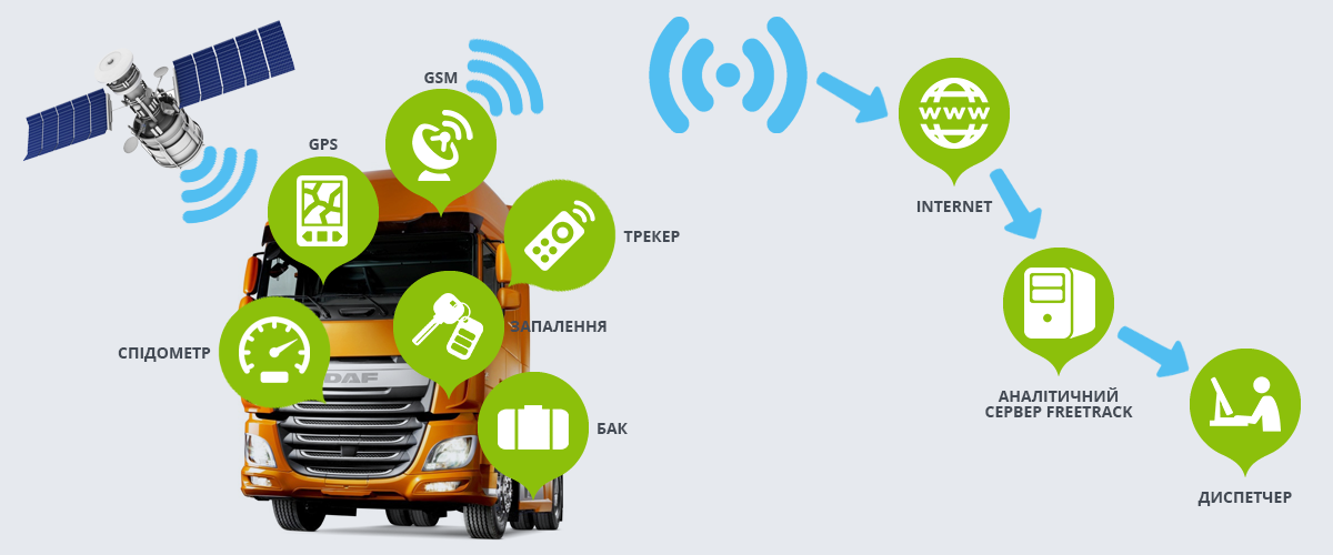
Four cornerstones of system FreeTrack
The monitoring system FreeTrack operates four modern technologies: GPS, GSM, GPRS the Internet. In the vehicle mounted device with activated sim-card of any GSM-Ukrainian operator. The fuel sensor (optional) , alarm button, alarm etc. can be connected along with GPS and GSM antenna. Integrated device is programmed for FreeTrack monitoring system for further processing.
The principle of operation FreeTrack:
- GPS-receiver calculates its own position by measuring the time when the signal was sent from GPS-satellites. Each satellite constantly sends a message that contains information about the time of sending the message, the point in the orbit of the satellite from which the message was sent (ephemeris), and overall system status and estimate the orbits of other satellites grouping system GPS (almanac). These signals are spread with the speed of light in the universe, and with a little less speed through the atmosphere.
- GSM-device is connected to the national operator (or any operator, if the vehicle is abroad, in roaming) and for the GPRS system sends the coordinates (for information about fuel, panic button, temperature regimes, etc.) to the server FreeTrack, where the data are processed (applied to the maps generated emergency messages, reports, etc.).
- To get all the necessary information to the operator (logistics, freight forwarder, car owner, customer) you just need to sit at the computer connected to the Internet and log on to the website http://gps.freetrack.com.ua/ under your username and password (which is assigned by an administrators). Thus the operator in real time can monitor the vehicle (generate reports, view old routes, form a geofence, etc.).
- GPS, (Global Positioning System) is a set of satellites with radio-frequency receiving and transmitting equipment and is run on the order of the military Department — the Department of Defense, used to determine the location of an object on the Earth’s surface during missile guidance to the target and coordinate the movement of units of the aviation, marine and land-based.
- GSM, (Global System for Mobile Communications) is an international standard for digital mobile cellular communication with the separation channel on the TDMA principle, and a high degree of security through public key encryption. lar division channel TDMA principle and a high level of security through public key encryption. The standard was developed under the auspices of the European Institute for Standardization (ETSI) in the late 80s.
- GPRS, (General Packet Radio Service) standard, which uses the non-occupied voice communication bandwidth for data transmission. It is used in mobile devices to transmit MMS, WAP browsing and the full internet connection. voice communication bandwidth for data transmission. There are classes from the first to the twelfth — a device with the higher the class can provide the greater data transfer rate.
- The Internet (Internet, literally — “firewall”) is a global system of voluntarily joined computer networks, based on the use of IP and routing of data packets. Internet creates a global information space, serves as a basis for physical access to many websites and systems (protocols) data.
- Geofence is a geographical area which is determined by a variety of geographic locations with GPS dinates, located in the geographical region with the specified center. Geofence can have a shape of circle, square or polygon. The boundary of the geofence is determined by a virtual line which is drawn along the perimeter. It is believed that the device (GPS antenna) left the geofence if the coordinates are lost or it has been moved out of the area.